Learning Objectives
After completion of this lab, you will be able to:
- Apply foundational knowledge of the nature and complexity of the hydrosphere and geosphere, as well as research skills, in order to understand a landscape that is important to you.
- Observe imagery of a location and identify characteristics of the local hydrosphere and geosphere.
- Describe anthropogenic impacts on the hydrosphere and geosphere.
Introduction
Social, cultural, economic, and environmental sustainability is only possible if our practices properly take into account the way in which Earth’s spheres operate and interconnect. Throughout this course we have focused on processes involving the cycling of water near earth’s surface as well as those impacting landforms and the mineral material that they are composed of. We have also seen how these processes involving the geosphere and hydrosphere interconnect with the atmosphere and biosphere. This lab will ask you to reconnect with the geography of the place in which you live with the new knowledge that you have developed throughout the semester. Identifying the natural and anthropogenic features of the landscape, and being able to identify ways in which a change in one aspect of the land may affect all others is the central skill of this course.
There are no Pre-Readings for this lab because it reviews all the concepts that you have learned in this course, so perhaps an overview of your textbook will be useful as you complete this lab.
Lab Exercise
This lab asks you to focus on a small area of land that is important to you. You will be first using all of the skills that you have developed to create a map of your area of interest, then you will be demonstrating your knowledge by annotating two images of your area of interest. We will call your area of interest your “study area”.
You should spend no more than 3 hours on this laboratory assignment. A very good grade (up to B+) can be acquired just by using the sections of your textbook that you have studied in this course. However, an outstanding grade will require a little research or supplemental learning within your textbook. You may want to refer to ecological, forestry, geological, or surficial geology maps of your area. Or else, you may choose to find a paper about a feature within your study area.
Here is a MSWord template that may save time in formatting the assignment.
Step 1: Creating a map of your study area.
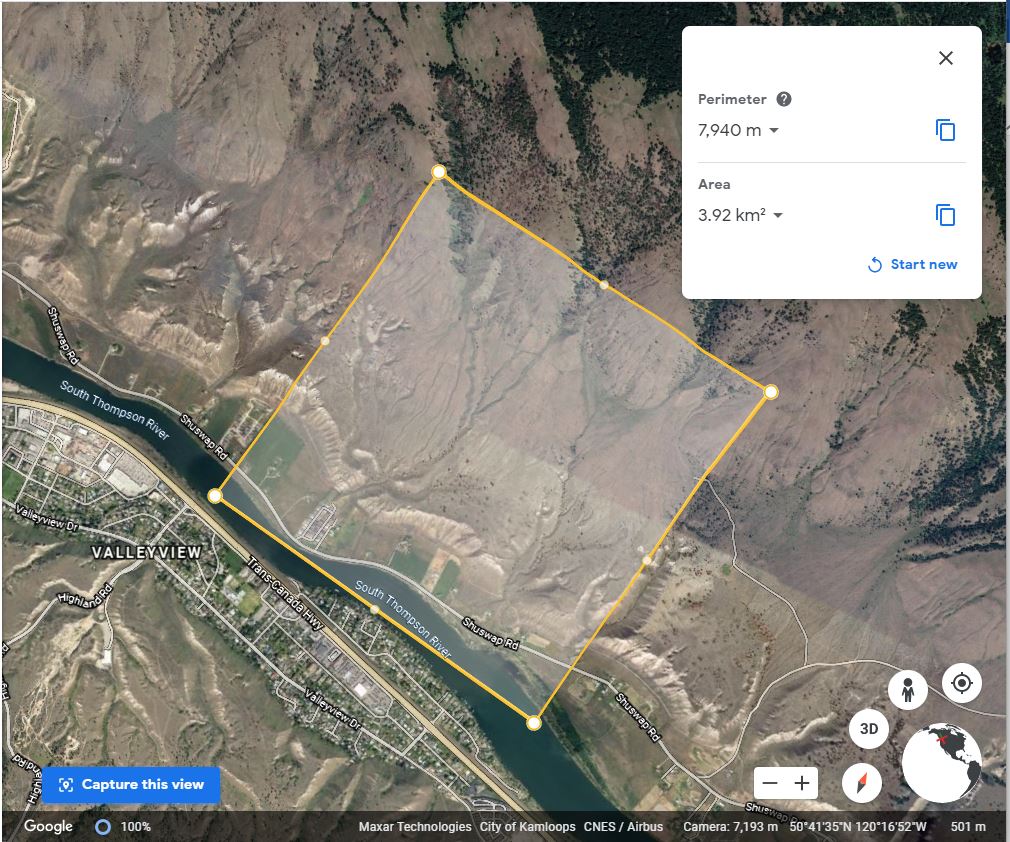
- Open Google Earth (web) and choose a 2km x 2km area on the Earth’s surface that is important to you.
- Start a new project and measure a 2km x 2km field area by using the measure tool to create a square with a perimeter of approximately 8 km and area of 4 km.
- Unlike figure 1 below, ensure that north is up (press compass symbol).
- Take a screenshot of your measurement and add this as Figure 1 to a text document.
Step 2: Writing figure 1 caption
- Write a caption for figure 1 and include the following
- The coordinates in decimal degrees of the approximate center of your field area.
- A written description of where your study area is located referring to place names and landmarks.
- A territorial acknowledgement. In other words, a description of which First Nations a have traditionally lived within the land (the territory) and whether the territory is unceded or not. At a minimum, you may want to refer to the links (they pop up within bubbles once you click on the map) provided by this site to verify.
- A description of why this area is important to you.
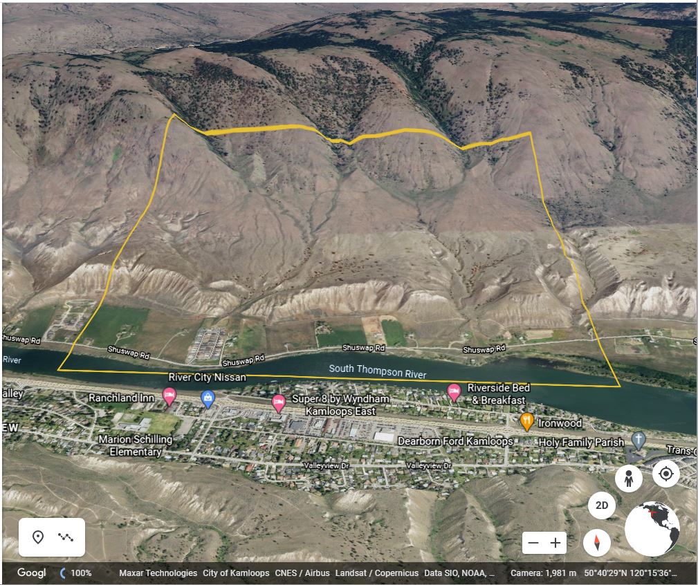
Step 3: Including photograph or an oblique GoogleEarth view of your study area.
- Please construct figure 2 of your lab assignment by including a photograph of your study area. If you are using the same study area that you visited for lab 1, you may choose to revisit your study area to observe changes in the months since lab 1, or you may choose the photograph that you took in lab 1. If you do not have a personal photograph of the study area, please rotate the view in Google Earth of your study area in 3D view (button in lower right-hand corner). Then, by using the shift button, rotate the view in order to allow the viewer to understand the variations in slope and vegetation within your study area as well as the surrounding watershed. If you are using a personal photograph, draw on the photograph the approximate bounds of your study area.
Step 4: Documenting your observations of the hydrosphere.
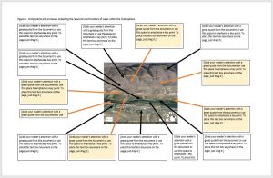
Figure 3 will be an annotated photograph of the components and processes impacting the hydrosphere that you may infer are occuring within the landscape. Include both human impacts and less anthropogenic processes and components.
- In order to create figure 3 on page 3 of your document, in MS word create a section break on a new page in your document (“Layout” tab > “Breaks” button > Section Breaks: Next Page). Change the size of the paper to 11×17. Then, change the orientation of the paper to landscape view.
- Paste your image from figure 2 in the middle of the page so that it takes up 1/9th of the area of the page. In order to help with formatting your document, highlight the picture, press the “Picture Tools” tab then choose “Wrap text” > “In front of text”.
- Create a figure caption describing that this figure illustrates the components and processes impacting the reservoirs and transfers of water within the hydrosphere.
- Annotate your photograph by creating textboxes and arrows of the components and processes impacting the hydrosphere that you may infer are occuring within the landscape in your study area.
-
- Please fill annotations focussing on any human impacts in light yellow with orange arrows. Other components can be left black and white. Please note:
- All textboxes must contain full sentences.
- If any textbox contains information taken from research you did by referring to a supplementary source, please create a footnoted citation including all the same information as APA format.
- Be sure annotate evidence of natural processes and human impacts on:
-
-
- evapotranspiration
- evaporation
- percolation
- infiltration
- interception
- groundwater table and flow
- runoff
- stream flow
- flooding
- snowfall and melt
- precipitation
-
-
Step 5: Documenting your observations of the geosphere.
Figure 4 will be similar to Figure 3 except that it will focus on the geosphere. Figure 4 is an annotated photograph of the components and processes impacting the geosphere that you may infer are occuring within the landscape. Include both human impacts and less anthropogenic processes and components.
- Paste your image from figure 2 in the middle of a new page (page 4) so that it takes up 1/9th of the area of the page. In order to help with formatting your document, highlight the picture, press the “Picture Tools” tab then choose “Wrap text” > “In front of text”.
- Create a figure caption describing that this figure illustrates the components and processes impacting the reservoirs and transfers of mineral material within the geosphere.
- Annotate your photograph by creating textboxes and arrows of the components and processes impacting the geosphere that you may infer are occuring within the landscape in your study area.
-
- Please fill annotations focussing on any human impacts in light yellow with orange arrows. Other components can be left black and white. Please note:
- All textboxes must contain full sentences.
- If any textbox contains information taken from research you did by referring to a supplementary source, please create a footnoted citation including all the same information as APA format. You may was to research if there are any surficial geology maps of your area
- Be sure annotate evidence of natural processes and human impacts on:
-
-
- bedrock
- areas of erosion and type of erosion (eg. fluvial)
- areas of transportation of mineral material and type of transportation (suspended load, bed load, type of mass movement, anthropogenic or not eg. cuts into the slope)
- areas of deposition (anthropogenic or not eg. fill)
- mass movements including creep
- weathering (physical or chemical)
- compaction
- landforms including
- Mass wasting landforms: slumps, flows, avalanche, fall (talus)
- Fluvial landforms and deposits: drainage divides, floodplains, fluvial fans, deltas, V-shaped valleys, fluvial terraces, point bar, cutbanks etc.
- Glacial landforms: U-shaped valleys, alpine landforms, moraines, kettles, kames, eskers, outwash plains
- Anthropogenic landforms (cut, fills, levees, dams, landfills)
- soil development.
-
-